Calibration validaton results of the Compact Infrared Camera (CIRC) onboard DAICHI-2
In the calibration validation phase of the CIRC, we measured an on-orbit Modulation Transfer Function (MTF) to confirm the imaging quality of the CIRC. We also confirmed the temperature accuracy of the CIRC observation data is within ±4K.
On-orbit imaging quality
The imaging quality of the CIRC is confirmed by the measurement of the Modulation Transfer Function (MTF). The MTF measurement in the ground calibration is shown in CIRC papers.In order to confirm the on-orbit imaging quality (on-orbit MTF), we used a knife edge method. The knife edge method uses a slant edge pattern on the ground. As this method requires a high contrast target, we selected an artificial lake on the border of Iran-Iraq. Figure 1 shows the CIRC image of the edge between the lake and the desert. From the edge pattern in Figure 1, we extracted edge split function (ESF). Figure 2 shows the ESF calculated form the edge image in Figure 1. The horizontal axis of the ESF shows the distance from a pxiel to edge, while the vertical axis shows the output digital number of the pixel. By differentiating the ESF, we obtained a line split function (LSF), which is shown in Figure 2. The MTF is obtained from the LSF by Fourier transform. We confirmed that the on-orbit MTF is almost consistent with that of the ground calibration.
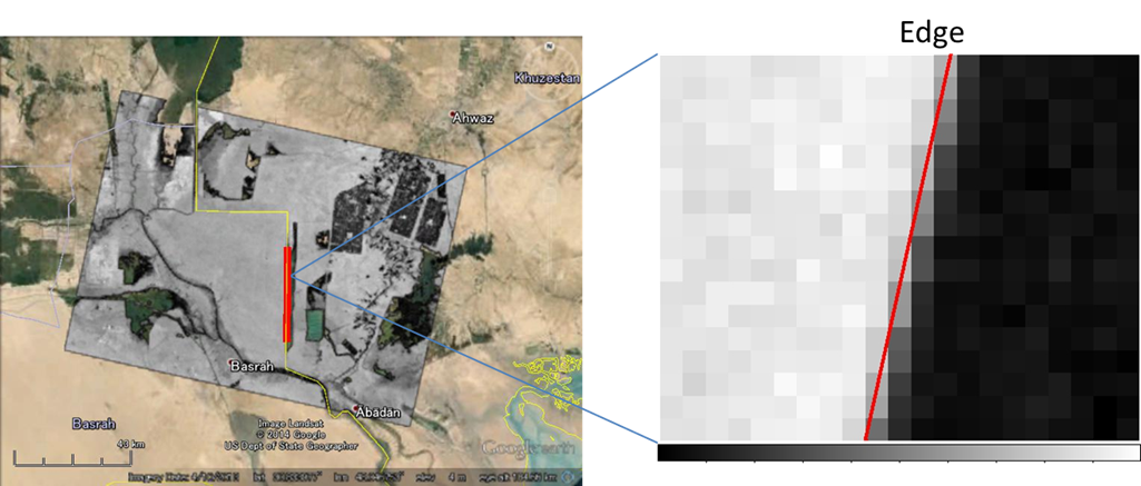
Figure 1 Edge image taken by the CIRC (Daytime image of the border between Iran and Iraq).
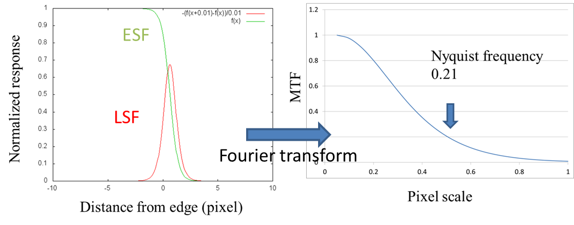
Figure 2 (Left) Edge Split Function(ESF) and Line Split Function(LSF) extracted from Figure 1. (Right) Modulation Transfer Function(MTF) obtained from the LSF by Fourier transform.
On-orbit radiometric quality
On-orbit radiometric quality is confirmed by vicarious calibration. Objectives of vicarious calibration are to confirm the correction method with shutterless system and absolute temperature accuracy (less than ± 4 K @300 K) . Vicarious calibration is an on-orbit technique in which calibrated sensors take simultaneous measurements of a spectrally or spatially homogeneous target during periods satellite instrument overpasses. Following three types of data plan to be used for our various calibration.
- Automated validation stations data and ground experiments data
- Airborne data with CIRC ground test model (GTM)
- Other satellite observation data
Here, we show the results of the vicarious calibration using automated validation stations data and ground experiments data. Vicarious calibration is conducted in a temperature-based method in which the surface temperature and spectral emissivity of a site are measured, and used for prediction of the top of the atmosphere (TOA) radiance. In this method, atmospheric profiles (air temperature, humidity, etc.) are necessary to calculate radiative transfer. In the CIRC vicarious calibration, a few sites such as Lake Kasumigaura, Lake Tahoe, and Lake Shinji-ko are used as automated validation stations. Ground experiments at Lake Kasumigaura and Railroad Valley playa are also conducted to take in-situ data in cooperate with Tonooka Laboratory, Ibaraki University, Japan. Figure 3 shows the relation between observed CIRC data and predicted TOA brightness temperatures. Bule circles and purple crosses in Figure 3 (left) represent uncorrected and corrected data based on the vicarious calibration, respectively. From the vicarious calibration, we found that absolute temperature accuracy is less than ± 3.3 K (3σ) as shown in Figure 3 (right). In the next phase, we aim temperature accuracy less than ± 2 K @ 300 K in combination with airborne observation with CIRC GTM and other satellite observation data. The details of the vicarious calibration are shown in CIRC papers.
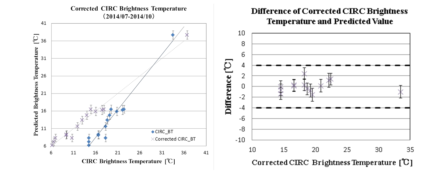
Figure 3 Relation between observed CIRC data and predicted values Brightness Temperature.